The Desert at War
Patton's Desert Training Center
To ready an army for the deserts of North Africa, General George S. Patton Jr. turned the country around Vidal into the largest military training ground the world had ever seen — a simulated theater of war spread across thousands of square miles.
By early 1942, Axis forces were driving the Allies east across North Africa. On January 29 the Germans recaptured the port of Benghazi, and within a week Rommel's armor had driven a hundred miles back toward Egypt. Planners in the War Plans Division of the War Department General Staff looked at the map and saw a nightmare taking shape: if the Afrika Korps pressed on and the Japanese broke through in India, the Axis powers might join hands in Persia and fight on into the Caucasus. The campaigns in North Africa — like the earlier disasters in Norway, Albania, and Crete — had proved that success in modern war belonged to troops specially organized, trained, and equipped for the ground they had to hold. The United States Army had no such troops for the desert.
On February 5, 1942, Lt. Gen. Lesley J. McNair, chief of staff of General Headquarters, endorsed the recommendation to build a place that would make them. The mission — to teach mechanized units to live and fight in the desert, to test and develop equipment fit for it, and to work out the tactics and training methods no manual yet contained — fell to the Army's most aggressive armor commander. General Headquarters named Maj. Gen. George S. Patton Jr., commander of the I Armored Corps, as the Desert Training Center's first commanding general, and ordered him to go find its ground.
Four days over the desert
Patton arrived at March Field, California, by air, and from March 4 through March 7, 1942, he reconnoitered southeastern California and western Arizona from both the air and the ground, accompanied by Colonels Devine, Gaffey, and Gay and Lt. Col. Muller of the I Armored Corps, together with two representatives from GHQ. He concentrated on two parcels of land. Parcel "A" ran from the California bank of the Colorado River west to Desert Center, and from Searchlight, Nevada, in the north to Yuma, Arizona, in the south. Parcel "B" lay to the east of its southern portion. Patton quickly favored "A."
His reasons were practical to the point of ruthlessness. Parcel "A" held a better water supply; 79.3 percent of it was federal land under the Department of the Interior, and privately patented ground came to just 1.5 percent — mostly mining claims in country too broken to maneuver, and easily avoided. At roughly ten thousand square miles, with a usable width of ninety miles and a length of one hundred eighty, it dwarfed "B," and it was served by three railroads: the Union Pacific in the north, the Santa Fe through the center, and the Santa Fe and Southern Pacific in the south. The Santa Fe main line was the one that mattered most for the eastern desert, running past the little siding at Vidal and its neighbor Earp on its way to the Colorado River — so that the same rails and the same crossroad that had carried aqueduct crews a few years earlier now sat squarely inside Patton's chosen ground.
Patton did more than look over the land. At a conference at the Metropolitan Water District office in Los Angeles he dominated the room; when a civilian suggested his soldiers build water storage, he replied that troops had no time to build anything — they had to learn how to fight, and would be given a week's notice before water was needed. He arranged electric power from the district's aqueduct lines, telephone circuits into Indio, and — insisting on no female operators at the camps — a switchboard controlled some sixty miles away at Whitewater. He set his base camp a little over twenty miles by road east of Indio, and reported to McNair that this was “probably the largest and best training ground in the United States.”
A theater the size of a war
What began as ten thousand square miles did not stay that way. As the mission broadened from desert training into full-scale maneuver, the ground grew with it, ultimately spreading across roughly eighteen thousand square miles of California, Arizona, and the southern tip of Nevada — the largest military training installation on earth. Later planners divided the theater into lettered maneuver areas: Area “A,” the original heart of the center, at some ten thousand square miles; Area “B,” reaching east into Arizona, at more than six thousand; and the smaller Area “C” around Kingman, near fifteen hundred.
Camp Young and the Spartan life
Patton's base was Camp Young, laid out on the open desert east of Indio; divisional tent camps followed deeper into the country — Desert Center, Iron Mountain, Coxcomb, Granite, and the corridor running north and east toward Needles, the Colorado River, and the ground around Vidal. Camp Ibis rose near Needles at the northern end of that corridor, and the Vidal Valley — the broad basin between the Whipple Mountains and the river — became part of the theater's eastern maneuver ground, its Santa Fe siding a natural detraining point for men and matériel. Nothing about these camps was meant to be comfortable. The War Department directive had authorized no more housing than the bare minimum for health, sanitation, and the safeguarding of property. Men lived in tents on rationed water and maneuvered across terrain that was anything but the popular image of level sand: dry lake beds, rock and crag, and mountain chains that sprang precipitously from the desert floor, some rising more than seven thousand feet.
The heat was punishing — as high as 130 degrees in the shade, with only mesquite, creosote, and cactus for cover — but the swings in temperature tried men and machines even harder. In winter the thermometer might climb from near freezing at dawn to a hundred degrees by midday. Soldiers learned to read the ground, to conserve every canteen, and to disappear into it. Concealment was a discipline in its own right: a command post might vanish into the thin shade of a single ironwood tree.
The training was relentless and, by design, as close to war as peacetime allowed. Antiaircraft regiments drilled in the open, men dug into foxholes against simulated air attack, and units rehearsed the routine of survival under a sky an enemy was assumed to own.
Training as close to war as peace allowed
For the months he held command, Patton drove the I Armored Corps mercilessly across the sand and rock, working out the tactics of massed armor and combined arms that he would soon carry into Tunisia and Sicily. Columns of M-3 light tanks churned across the flats in clouds of their own dust, learning to move, disperse, and strike as a mass rather than a scatter of single machines.
First came the armored infantry, advancing in half-track troop carriers, leaping from their vehicles, storming enemy strong points with fixed bayonets… Then came the swarms of tanks, smashing everything before them.
A maneuver at the Desert Training Center, described in Yank, September 1942
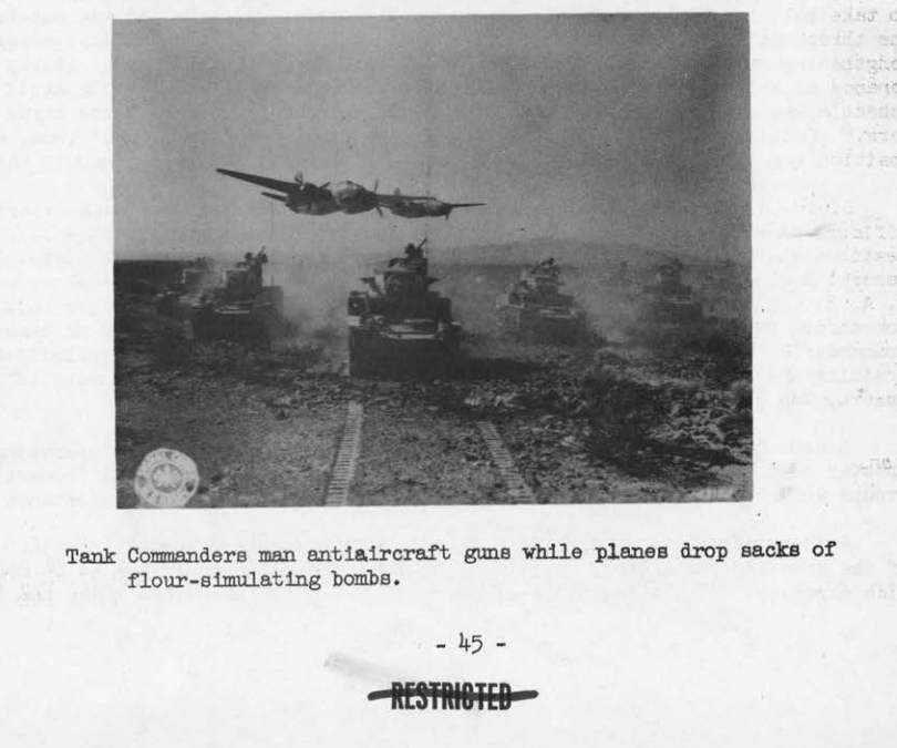
Live fire made the lessons real. Aircraft dropped sacks of flour to stand in for bombs while tank crews manned their antiaircraft guns; automatic weapons hammered at towed targets after dark, so that the theater's nights were laced with tracer. It was training that spent ammunition freely and asked men to trust one another under conditions that left little room for pretending.
Supply across an empty land
The desert punished planners as surely as it did privates. Water, fuel, food, and spare parts had to be pushed to units strung out across a theater the size of a small country, and the effort to do it became a training exercise of its own. Engineers laid portable pipelines over the ridges to reach water; one such line ran seven miles from a rise down to the storage tanks of the Santa Fe Railroad.
The Colorado River, the theater's eastern edge, was both an obstacle and a classroom. Along the very reach that runs past Vidal and Earp, engineer units threw pontoon bridges across it and rehearsed the improvised crossings a campaign might demand — even floating trucks over the water on tarpaulins when no bridge was at hand. The same water the aqueduct crews had dammed and diverted a few years before now trained an army to cross rivers under fire.
Where roads and rails could not reach, aircraft did. Transport planes dropped supplies by parachute to ground units marked by signal panels — a technique that would matter greatly in the campaigns to come.
Keeping men and machines alive
Dust and heat were merciless on equipment. Engines overheated, seals failed, and final drives packed with grit; maintenance in the field became a constant, filthy struggle carried out with the tank half-buried in sand. Recovery crews learned to drag heavy vehicles out of the dry washes that could swallow a machine in minutes, work that would translate directly to the battlefields ahead.
Men needed tending as much as machines. As the center grew into a full theater, it built its own medical system — station hospitals of canvas wards pitched in rows on the sand, where the sick and injured were treated and, when necessary, staged for evacuation.
Morale was its own kind of supply. On Sundays the ranks gathered by the thousands in the open desert for field chapel services, kneeling in the sand before shipping out to a war many of them would not survive.
Patton's proving ground
Then, as abruptly as he had come, Patton was pulled away in the summer of 1942 to help plan the invasion of North Africa, taking the tactics he had forged in the Mojave straight to the enemy who had inspired the center's creation. His successors inherited a training ground still finding its shape — and, at first, a good deal of confusion, for no standing organization had been left to hold administrative matters together between commands.
Under Maj. Gen. Alvan C. Gillem Jr. and the II Armored Corps, and then a succession of later commanders, the concept broadened dramatically. Rather than a simple training camp, the Army rebuilt it as a simulated theater of operations — the first in the United States — with a communications zone to link scattered commands, its own supply and hospital systems, and full-scale corps maneuvers ranging over thousands of square miles. At its height the population of the theater swelled to roughly 190,000 soldiers, and over its two years more than a million men passed through it.
On October 20, 1943, to make clear that its purpose had outgrown desert warfare alone, the Army renamed it the California-Arizona Maneuver Area. Commanders such as McNair judged the combat training there the best in the country: here, uniquely, a general could maneuver an entire corps across open ground, and the friction of real war — breakdowns, fatigue, the endless struggle to supply men strung across the desert — did not have to be simulated. It was simply endured.
The desert closes the camp
By late 1943 the tide of the war had turned. North Africa was won, and the divisions hardened in the Mojave were shipping overseas faster than they could be replaced. A worsening shortage of service units, which could not be reconstituted once sent abroad, compounded the problem. In December General McNair recommended that the theater be closed, and at midnight between April 30 and May 1, 1944, Maj. Gen. Jonathan W. Anderson turned the maneuver area over to the Army Service Forces. The tents came down and the soldiers were gone.
What they left behind proved surprisingly durable. Scattered across the BLM-managed desert around Vidal and its neighboring camps are the ghostly outlines of that vanished army: rock-lined tent streets and company alignments, unit insignia spelled out in stone, the scars of tank tracks, mock battlefields, and the small rock altars soldiers built for the field chapel services before shipping out to war. Many of the men who trained here returned to the desert to live once the war was over — and the weathered remnants they left still rest in the sand today, a battlefield in America's own backyard.
No official camp was ever platted in the Vidal Valley itself, but the town sat within easy reach of the training ground and its nearest bases: Camp Rice, established in 1942 some eighteen miles to the west and used only briefly that fall by the 5th Armored Division, and Camps Granite and Iron Mountain, roughly thirty-seven and forty miles off. The desert around Vidal was open maneuver country, free for units to range across as they saw fit. By the time the last rotation left in the spring of 1944, more than 2.2 million military personnel had trained and cycled through the DTC and California-Arizona Maneuver Area.
Clearing the ground after the war
The camps closed in 1944, but the Army's work on the desert did not end there. On June 6, 1947, 1st Lt. C. R. Joseph Sainato of the Bomb and Shell Disposal Team reported that a week-long operation had inspected 120 acres of the Spillane Property at Vidal for land mines and “other dangerous objects.” Two-man teams worked with three detectors. The total cost recorded in the letter was $762.
The search found four fused M1 practice antitank mines, filled with black powder and red phosphorus. The team destroyed them in place with Composition C-3 charges. Sainato's letter concluded that the property was “free from explosives for the purpose of grazing and cultivation”—a statement tied to the intended use, not a claim that every kind of risk had been assessed for every future use. The map referenced in the letter is missing from the archive file, and the surviving record leaves open whether the Spillane Property was later listed as a Formerly Used Defense Site or simply marked clear and removed from consideration.
The war game returns: Exercise Desert Strike
The soldiers came back once more. In May 1964, twenty years after Patton's men had gone, the same stretch of the Mojave became the battlefield for Exercise Desert Strike, a vast Cold War war game staged across roughly thirteen million acres from Barstow east to Kingman, Arizona, and from below Las Vegas south to Blythe. Two joint task forces — more than 100,000 airmen and soldiers, over 900 aircraft, and more than 500 tanks — fought a mock two-week campaign under U.S. Strike Command, one that even rehearsed the use of tactical nuclear weapons.
The Colorado River was again the line of battle. With its dams and bridges ruled destroyed by the umpires, the attacking task force had to force the river along a 140-mile front at seven crossing sites, each two to three miles wide. One of those crossings appears to have been staged directly opposite the mouth of Vidal Wash: a 1964 photograph of troops preparing to cross shows a three-pole power line, a shoreline pole, and a pole-lined road whose features still matched aerial imagery of the spot decades later. Half a century after the aqueduct crews and Patton's tanks, the ground around Vidal was pressed into service as a theater of war one final time.
Photographs from the desert
22 archival images
Sources & Further Reading
- Sgt. Sidney L. Meller, "The Desert Training Center and C-AMA," Study No. 15, Historical Section, Army Ground Forces (1946) — including the report's photographs and maps reproduced here.
- Matt C. Bischoff, "The Desert Training Center / California-Arizona Maneuver Area, 1942–1944: Historical and Archaeological Contexts," Technical Series 75, Statistical Research, Inc.
- National Park Service, "Patton's Mojave: The Desert Training Center."
- Bureau of Land Management — 80th anniversary of the Desert Training Center / California-Arizona Maneuver Area.
- War correspondent's account of a DTC maneuver, Yank, September 1942 (quoted in NPS materials).
- UXO News Wire Service, ‘Where are They Now? Some Pre-FUDS Properties Remain a Mystery’ (November 24, 2015), reporting on the 1947 Spillane Property clearance letter and photographs.